
By Max Webb, Managing Director of Pricing Analytics
Just like that, summer 2024 has arrived. While the summer solstice is still a couple of weeks away, meteorological summer runs from June 1 through August 31. Already nearly half-way through the year, where does the time go? We all know how busy summers can be – planning for school vacation, summer trips, and holiday barbeques – but don’t forget to check the weather!
With so little time and so much to do, let’s cut to the chase. Here is what you need to know weather-wise for this summer: it’s going to be hot and it’s going to be a busy hurricane season, both of which are influenced by the El Niño–Southern Oscillation (ENSO) and the transition from El Niño to La Niña.
It is Going to be a Hot One!
Weather experts and forecasting models agree that it is going to be a hot summer for most of the country. Here are a couple of recent headlines and comments from weather experts:
“…probable switch from El Niño to La Niña increases the risk of a hot summer and possibly the hottest on record.” – Washington Post
“We can expect an abnormally hot summer this year, according to Dr. Todd Crawford, Vice President of Meteorology at Atmospheric G2… In fact, there are signs in the long-range models and climate trends that this could end up being one of the hottest summers on record.” – The Weather Channel
As for the forecasting models, Figures 1 and 2 show the National Oceanic and Atmospheric Administration (NOAA) June-July-August forecast is similar to the European Centre for Medium-Range Weather Forecasts (ECMWF) forecast for the same time period.
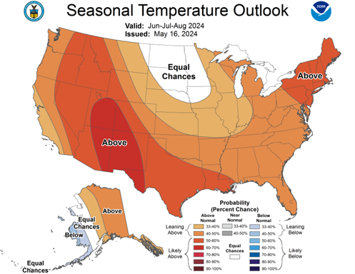
Figure 1: NOAA Jun-Jul-Aug 2024 Seasonal Temperature Outlook

Figure 2: ECMWF Jun-Jul-Aug 2024 Temperature Anomaly Probability Outlook
Both models show a high probability of above average temperatures for much of the country. The dark orange and red areas in the southwest and east/northeast are the most likely to be above average. The orange and yellow areas are still likely to be above average by summer’s end, but with slightly less confidence. Both models are also in agreement that parts of the central U.S. are just as likely to be average, below average, or above average.
While similarly titled, Figure 3 is the ECMWF model’s attempt at forecasting how above average or below average temperatures will be this summer. Note, this graph shows temperature anomaly in Celsius, so for those not used to Celsius, a 1-degree Celsius variance is about equal to 1.8 degrees Fahrenheit.
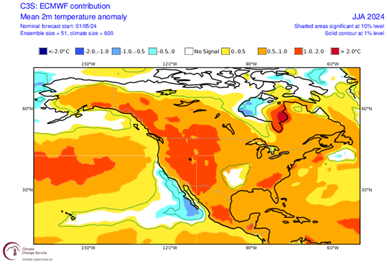
Figure 3: ECMWF Jun-Jul-Aug 2024 Temperature Anomaly Outlook (
Much of the country is shaded in the light orange, which would be between 0.5 to 1.0 degrees Celsius warmer than average. The areas in darker orange are between 1.0 to 2.0 degrees Celsius warmer than average. So, while most of the country will experience prolonged elevated temperatures, the western & southeast U.S. are forecasted to be especially hot. Again, the central U.S. is shaded in white, which means they are likely to experience a normal summer, which will still be plenty warm!
This Could be a Hurricane Season to Remember
Hurricane season 2024 officially began on June 1 and lasts through November 30. There has not been much storm or hurricane activity to date; however, don’t let a slow start to the season fool you. Most meteorologists and weather experts, such as AccuWeather and Colorado State University’s world-renowned Tropical Weather and Climate Research Group, are predicting the 2024 season will be one of the most active seasons on record. Figure 4 compares AccuWeather’s & Colorado State University’s 2024 hurricane forecasts to the average from 1991-2020.
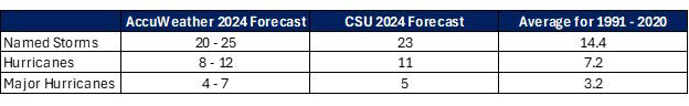
Figure 4: AccuWeather and Colorado State University 2024 Hurricane Forecast Compared to Average
To put these forecasts into perspective, CSU’s 2024 forecast would be the fifth most active hurricane season since 1966 if it were to come to fruition.
There are two major reasons driving those predictions: warm Atlantic Ocean temperatures and the transition from El Niño to La Niña. The Atlantic Ocean always warms up in the summer; however, this year is unique because the Atlantic Ocean temperatures are abnormally warm for this time of year and are forecasted to remain warm all hurricane season long. While that may bode well for summer beach trips, warm ocean waters are the main fuel source for tropical storms and hurricanes. The warmer the water, the higher the chances of more frequent and stronger storms.
El Niño to La Niña Transition
You may be thinking: if the hurricane season is expected to be so busy, why haven’t we seen much activity yet? We’ll have to turn to the Pacific Ocean temperatures for the answer. As covered in previous CES weather blogs, “Winter Weather Patterns, Europe’s Limited Gas Supply, Market Volatility, and the Impact on Energy Prices: What to Expect This Cold-Weather Season,” “Hurricanes, Heat and (CES Self) Help: What’s in Store for Summer!,” and “Winter Weather Forecast: Bearish or Bullish?,” the El Niño–Southern Oscillation (ENSO) largely influences global weather patterns.
There are three phases to ENSO: El Niño, La Niña, and neutral. El Niño is when Pacific Ocean Sea surface temperatures are above average, and La Niña is when the sea surface temperatures are below average. El Niño and La Niña are so important to global, and especially North American, weather because they influence atmospheric jet streams and wind direction. This past winter, ENSO was in the El Niño phase, which was the primary driver for the overall warm temperatures much of the U.S. experienced.
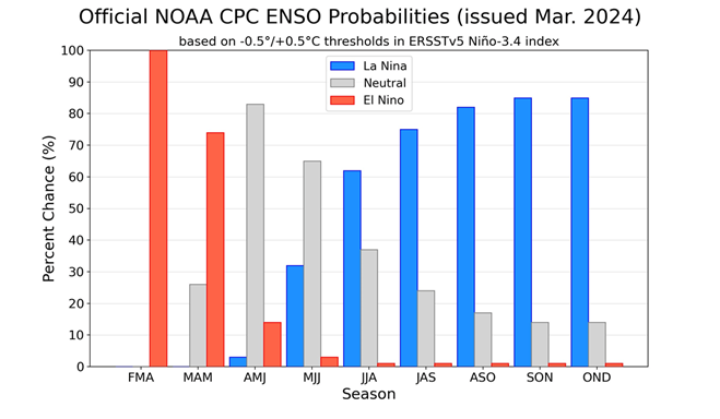
Figure 5: ENSO Probabilities
Figure 5 shows that El Niño is currently fading to neutral (phase between El Niño and La Niña) and is forecasted to fully transition to a La Niña later this summer and last through the upcoming winter.
During an El Niño, tropical trade winds blow west to east, which blow against and weaken Atlantic storms traveling east to west. On the other hand, La Niña flips those winds to blow from east to west, which becomes an amplifying factor for tropical storms and hurricanes.
It may take another month or two until ENSO has fully transitioned to La Niña, so until that happens, the west to east El Niño winds will help keep storms at bay. Once La Niña arrives, keep an eye on the Weather Channel because if those hurricane season forecasts are accurate, it will be an active late summer through the end of November.
The transition to La Niña also plays a factor in air temperature. Upper-level ridges are atmospheric systems that typically mean warmer temperatures and little precipitation. Upper-level ridges occur every summer; however, they are more frequent during La Niña summers. This added influence is another reason tilting forecasts above average. The timing of the La Niña transition will play a large factor in how soon or late the tropical activity and extreme heat will arrive.
CES Recommendations
There is a clear consensus among weather experts that it is going to be a hot summer with extreme weather events. As your trusted energy advisors, it would be unthinkable if this blog did not end with some energy related advice.
Expect these factors to play a part in causing energy market volatility both nationally and locally which will impact prices in both the near and long term. If you have not locked in your energy rates for the year to come, now may be an opportune time to take advantage of three-year low market conditions and avoid a potential market run-up.
It would not be a CES summer weather blog without plugging CES Self-Help Demand Response Program, which is intended to help our clients with facilities in New England avoid the ISO-NE system peak hour and lower their peak load contribution and corresponding capacity costs. If you are new to CES, or have not heard of this program, I invite you to read a recent blog by Andrew Price, CES President & CEO, titled “2023 ISO-NE Peak Load Hour and CES Self-Help Program Recap.” Also feel free to reach out to our Energy Services Advisory team to learn more. The CES Self-Help program is voluntary to participate in and without fees for our clients. If you’re already signed up, keep an eye out for our email and text notifications all summer long.
It is also safe to assume that your business and home will have higher than normal energy bills due to above average cooling degree days and energy consumption. It cannot hurt to build in extra room in your energy budget to keep the air conditioning running to stay cool!
Photo by: JD Syaits