
By Zack Hallock, Senior Energy Services Advisor
Focusing on seasonal and annual weather patterns may not be top of mind, but for some of us at Competitive Energy Services (CES) it’s critical to keep on the front burner. Whether we like it or not, climate trends and seasonal weather patterns are a critical focus when it comes to the world of energy rates on the real-time or futures market. Seasonal weather drives business consumer behavior patterns that push the energy demand conversation. More specifically, weather drives energy consumption in the wintertime, most often in a predictable manner. As winter approaches, CES actively consults internal teams and external experts to evaluate and compare upcoming weather predictions. Throughout the year, winter conditions remain a key focus in New England as we monitor past and projected weather cycles. CES and our clients are as prepared as possible for seasonal impacts and shifting commodity scenarios by staying in close contact with local and national weather experts, suppliers, and even local climate enthusiasts.
Part of this due diligence requires thoughtfully using data sources that are reputable, objective, and science based - avoiding data that could skew accurate predictions. Part of our analysis is considering what climate models are available and how they are used so that we can rely on these resources to correctly inform our discussions.
Predictive Models
There are two main models to be aware of: The Global Ensemble Forecast System (GEFS) and the Global Ensemble Prediction System (GEPS).
- The Global Ensemble Forecast System (GEFS) is the U.S. ensemble weather model developed by NOAA’s National Centers for Environmental Prediction. It runs multiple versions of the Global Forecast System (GFS) to estimate forecast uncertainty and provide probabilistic outlooks up to 16 days ahead.
- The Global Ensemble Prediction System (GEPS) is Canada’s ensemble model operated by Environment and Climate Change Canada (ECCC). It uses the Global Deterministic Prediction System (GDPS) as its base model to produce similar probabilistic weather forecasts.
The main differences are that GEFS is U.S.-based and uses the GFS model, while GEPS is Canadian and uses the GDPS model. GEFS typically runs more ensemble iterations and updates more frequently. Despite these differences, both systems are combined in the North American Ensemble Forecast System (NAEFS) to improve regional forecast accuracy. Personally, I like to compare the two models independently to confirm apparent trends or anomalies.
Through conversation and analysis, we begin to put a picture together of what the upcoming winter COULD look like. This allows CES to continue helping clients with energy procurement strategies and operational adjustments for the winter season.
Winter 2025-26 Chatter
During the La Niña o phase of what’s known as the El Niño-Southern Oscillation (ENSO) cycle, there are a few major changes that happen leading up to the winter months over North America. As a New England native, I can almost guarantee that the most nuanced predictions are for the northeastern United States and Eastern Canada.
- The Pacific jet stream continues eastward but moves closer to the equator, stretching from the International Date Line to the southwestern U.S.
- Jet stream winds across the U.S. flow more directly west to east.
- Storm tracks shift south, from the northern to the southern U.S. bringing with it that above average moisture in the middle atmosphere.
- Cyclone formations in the Pacific moves south and east, concentrating just off the coast of California which is why the pacific northwest is a skier mecca in La Niña winter phases.
These changes bring stormier, generally colder and wet winters to the Northwest and the middle continental U.S. The tricky part are the central northern and northeastern states as they often experience fewer storms, but when they do, the storms are significant. Increased air flows from the Pacific across North America and reduced cold air from Canada leads to milder winter conditions on average across the northern states and Western Canada.
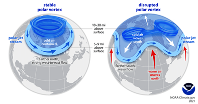
As highlighted two years ago in a CES blog titled “Winter Weather Forecast: Bearish or Bullish?,” do not count on weak heating demand lasting all winter. There is always uncertainty around potential Sudden Stratospheric Warming (SSW) events. Those events can be instigated by a shift in the Quasi-Biennial Oscillation (QBO). While SSW events are rare, they always dramatically alter North American temperatures by disrupting the polar vortex and pushing the jet stream south. Both El Niño and La Niña phases can trigger SSW events, though El Niño patterns may amplify their effects through QBO interaction.
Wondering what you need to know? Models currently predict La Niña to start the winter and a rising likelihood of an El Nino pattern in the later half of winter. SSW events are an important wildcard and should be closely monitored.
Figure 1 – Breakdown of Polar Vortex Due to Upper Atmosphere Sudden Stratospheric Warming Event (SSW), National Oceanic and Atmospheric Administration
The QBO is a stratospheric wind cycle that alternates between westerly (positive) and easterly (negative) phases roughly every 12–14 months. It has followed this rhythm reliably since 1980, with the latest shift indicating a new negative, or easterly, phase about 25 km above the equator.
If an SSW event is on the menu for this winter, it would likely drive up local and national energy prices, mainly in the near-term spot market. The futures market could see brief volatility, but prices should ease once milder spring temperatures return. These relatively unpredictable events that often result in cold intrusions will be critical to monitor this winter. For those with open energy positions, spot market exposure, or dual-fuel flexibility for arbitrage and fuel switching, this is what you are truly waiting for. In past El Niño winters with a negative QBO, the Northeast experienced several cold intrusions so the timing may be unknown, but the likelihood of these events happening is high. When these cold intrusions occur, we expect to see more price volatility in the natural gas market.
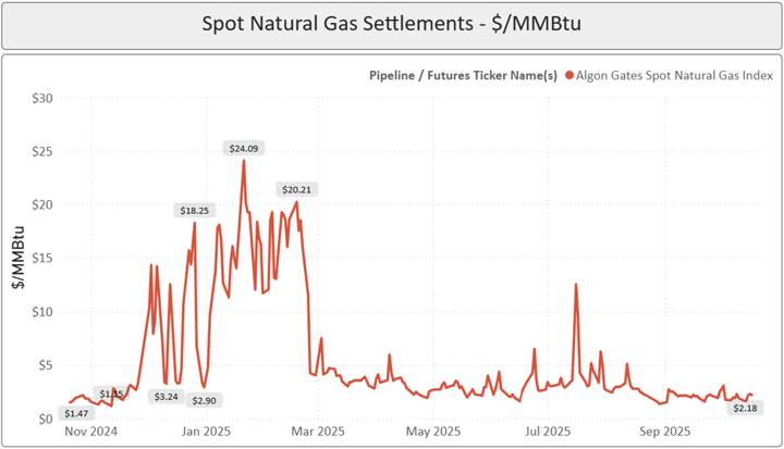
A good example was in early 2025 when a significant shift in seasonal weather patterns instigated prolonged spot market price elevation on the Algonquin Pipeline. That’s not to say weather was 100% of the cause of this elevated market but it was certainly a major driving factor as the United States heavily pulled from natural gas storage inventories at the onset of calendar 2025.
Figure 2 – Spot Natural Gas Settlements, November 2024 – October 2025, Competitive Energy Services, LLC
Check back on our article from 2023 to see how these pricing trends hold true over time. Winter Weather Forecast: Bearish or Bullish?
The Call | Weak La Niña (ENSO Neutral Leaning La Niña)
After much research and internal deliberation, it is safe to say that the call for this winter is as clear as a thick foggy day. Similar to this time last year, North America and Europe are facing a potential ENSO neutral or leaning La Niña forecast. We expect this ENSO phase to shift throughout the winter which further complicates a single call for the entire winter season and creates a first half and second half winter designation. We will be starting the winter with a heavy La Niña setup and it will shift closer to ENSO neutral and might even give us a glimpse of El Niño on the tail end of winter. As highlighted earlier this year, ENSO is not a singular phase. It operates in three distinct phases between El Niño La Niña and Neutral, most often oscillating on a three-to-five-year cycle.
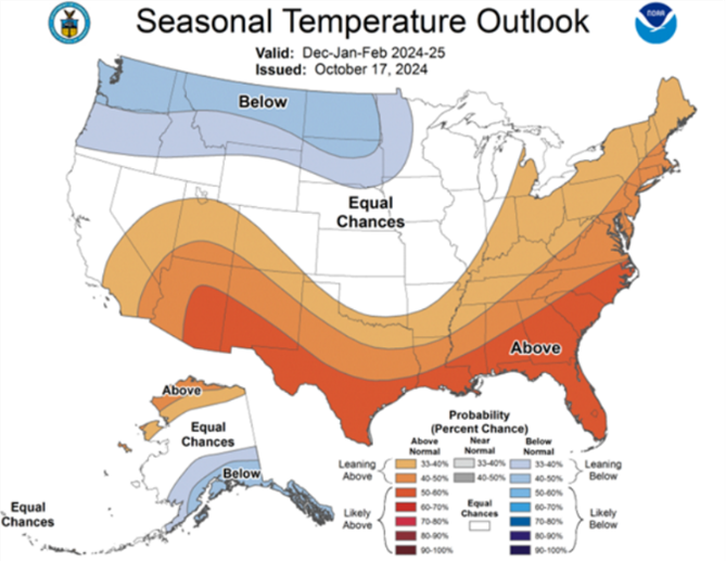
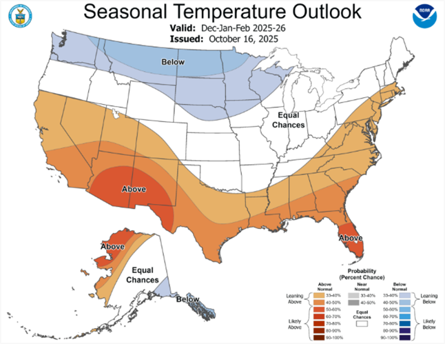
When we say this year is similar to last year, take a look at two NOAA 90-day outlooks dated mid-October 2024 and 2025 for the December-January-February timeframe in the ensuing winter. Given how winter 2024-2025 played out for the lower 48, it is safe to take this projection cautiously.
Figure 3 – 90-Day Seasonal Temperature Outlook, 2024-25, National Oceanic and Atmospheric Administration
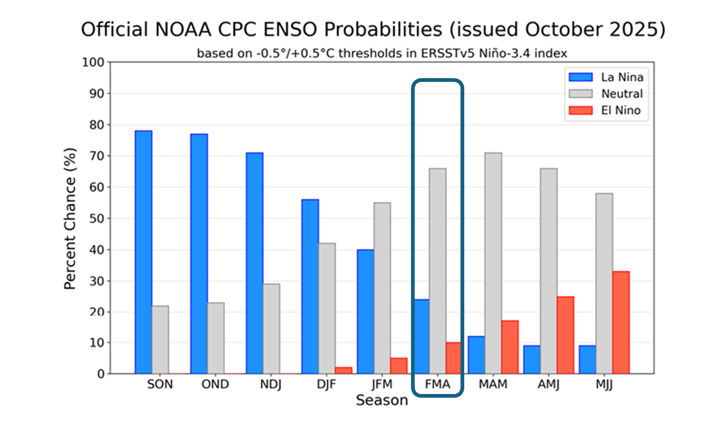
Figure 4 - 90-Day Seasonal Temperature Outlook, 2025-26, National Oceanic and Atmospheric Administration
Predicting weather is not an exact science but we can certainly make inferences based on historical data over the last 60+ years. Given last year was a weak La Niña winter or semi-ENSO neutral it is natural to lean toward the call that we are likely to have a similar winter for North America from the ENSO phase perspective. Interestingly though, the second-half of the upcoming winter appears to have ripe conditions to flip to El Niño, which is a warming of sea surface temperatures in the equatorial Pacific Ocean, as seen in Figure 5 below. Focus on the “FMA” block representing the 3-month period of February through April 2026. It is relatively uncommon to see a transition from La Niña to ENSO Neutral/Growing El Niño in the springtime. In a few words, it is uncommon for Sea Surface Temperatures (SST) to rise during this time of year because the northern Pacific Ocean is tilted away from the sun in the winter. That is why the northern hemisphere experiences winter in these months. Simply put, the tilt of the Earth’s axis is going to make it difficult for heat to build in the Ocean from the sun warming the surface of the Pacific in these springtime months.
Figure 5 – CPC ENSO Probabilities (October 2025), National Oceanic and Atmospheric Administration
Conclusion
Winter is a critical period for the energy market, particularly in the Northeast U.S., where limited natural gas pipeline infrastructure and grid constraints make prices highly sensitive to seasonal weather. Cold forecasts typically drive prices higher, while warm forecasts ease them. Over the past year, prices have remained somewhat volatile, driven by quickly changing or conflicting climate models. These models seem to agree on the lack of conviction for this coming winter for better or worse. If the current leading narrative for this winter holds, prices will be elevated to start the winter during the La Nina phase but soften at the tail end of winter as the ENSO phase shifts towards Neutral / El Nino. However, the array of climate models is predicting below-average temperatures for New England earlier in the season, which could send prices higher depending on timing and duration.
For those with open energy positions for winter 2025-26 and for winter 2026-27, do not rely solely on forecasts, be proactive. Best way to be proactive? Develop a plan to manage potential price spikes and contact a CES Energy Services Advisor to discuss strategies tailored to your needs.
Photo by Iiievgeniy