By Max Webb, Managing Director of Pricing Analytics
“Useful, with a pleasant degree of humor” is the message written on the cover of The Old Farmer’s Almanac.
I have always known the Almanac for its fun facts, stories and many other amusements, however, there are plenty of folks who have relied on the Almanac for hundreds of years for advice on life, gardening tips, food recipes, home remedies, and of course, weather predictions. Personally, I have never put much weight into their weather forecasts, but if it’s good enough for farmers, then it should be good enough for the CES winter weather forecast blog.
In keeping with the spirit of The Old Farmer’s Almanac, let’s have some fun and put the Alamac to the test. In this blog, I’ll be comparing the winter 2024-25 forecasts and predictions from the Almanac to the scientific industry standard, National Oceanic and Atmospheric Administration (NOAA). Come springtime, we will come out of hibernation to revisit this blog to see who was more accurate.
The Old Farmer’s Almanac
Starting with the first edition in 1792, The Old Farmer’s Almanac has been published every year since, making it the oldest almanac in American history. The Almanac’s first weather forecasts were created by its founder, Robert B. Thomas, who believed sunspots were responsible for influencing weather on Earth. Solar science, which the Almanac describes as, “the study of sunspots and other solar activity,” does in fact play a part in weather forecasting. Scientists have been monitoring the Sun’s solar activity for decades, and they have found that the energy emitted by the Sun increases and decreases over an 11-year cycle. More solar activity correlates with more energy emitted from the Sun which results in warmer temperatures felt on Earth. Just how much warmer? The difference in the Earth’s air temperature between maximum and minimum solar activity is a whopping 0.2 degree Fahrenheit. The Sun is currently near the maximum of its solar cycle, which should influence temperature forecasts ever so slightly warmer.
Over the years, the Old Farmer’s Almanac has adjusted and improved their methodology to incorporate more climatology and meteorology in their forecasting. According to the Almanac, their forecasts are historically 80% accurate. More recently, the Almanac’s forecast for last winter was only 64% accurate. Will this year’s forecast return to their historical norm, or will they miss the mark again?
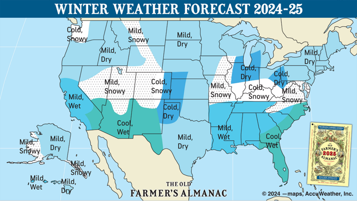
The Almanac is predicting a very warm start to the winter for the northeast U.S. with November averaging 5 degrees above normal. Warmer temperatures will stick around through December and January, which are forecasted to be 2 degrees and 2.5 degrees above average respectively. February is when the forecast first starts to show colder temperatures, averaging 2 degrees below normal. To close out the winter, warmer temperatures return in March averaging 2 degrees above normal.

Figure 1: The Old Farmer’s Almanac Winter Weather Forecast 2024-25 (https://www.almanac.com/winter-extended-forecast-farmers-almanac)
Overall, the Almanac is forecasting a mild winter for the northeast U.S. and for much of the country as shown in Figure 1. The Almanac is also forecasting slightly below average precipitation for the northeast U.S., which is something most New Englanders have grown accustomed to over the last few winters. This is bad news for winter outdoor recreation enthusiasts, but good news for those like me counting down the days until spring. But do not expect T-shirt and shorts weather all winter. There will surely be stretches of cold, most likely to occur in February. To put it in their own words, The Almanac’s short and sweet recap says, “In the Northeast… winter is always cold and snowy. But we’re predicting a gentler-than-normal season that’s not so rough and tough.”
National Oceanic and Atmospheric Administration (NOAA)
The National Oceanic and Atmospheric Administration (NOAA) was formed in 1970 by the United States government making it far “younger” than The Old Farmer’s Almanac (if you ignore any of NOAA’s predecessor organizations). NOAA is responsible for many important products and services including, “weather forecasts, severe storm warnings, climate monitoring, fisheries management, coastal restoration and supporting marine commerce….” If you’ve read any previous Competitive Energy Services’ (CES) weather blogs, like most other weather reporting bodies, we rely heavily upon data and forecasts published by NOAA.
To save you the same story we have shared in past CES weather blogs which detailed Pacific Ocean Sea surface temperatures, the El Niño Southern Oscillation (ENSO), and El Niño versus La Niña influences on winter weather, let’s dive right into NOAA’s forecast:
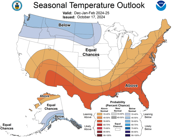
Like the Almanac, NOAA is also predicting a warm winter for the northeast. To start the winter season, November and December are forecasted to be about 2 degrees and 3 degrees above normal respectively. Heading into the new year, colder air is forecasted to move from Canada into the northern U.S., however, most of the cold will be felt in the pacific northwest and north central U.S. In the northeast U.S., the cold still has an impact as forecasts shift from solidly above average to only slightly above average temperatures for the second half of the winter. January is forecasted to be around 1 degree above average while February and March temperatures are forecasted to be 1 degree or less above average.

Figure 2: NOAA’s Seasonal Temperature Outlook for Dec-Jan-Feb 2024-25 (https://www.cpc.ncep.noaa.gov/products/predictions/long_range/seasonal.php?lead=2)
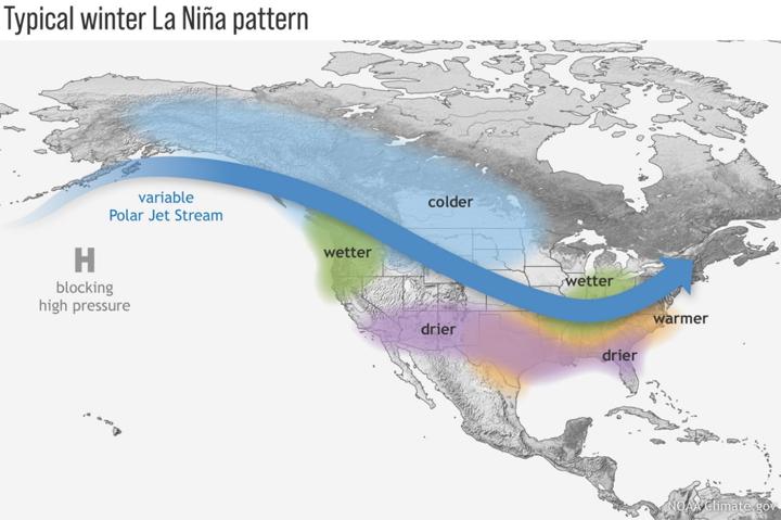
Okay, I lied. It turns out I could not get through a winter weather blog without discussing ENSO. NOAA is forecasting a weak La Niña to form this winter. As a result, NOAA’s winter outlook, shown in Figure 2 above, follows the typical impacts of a La Niña winter for the United States: above average temperatures across the southern U.S. and below average temperatures in the northwest and central U.S – as shown in Figure 3.

Figure 3: Typical Winter La Niña Pattern (https://www.climate.gov/media/14789)
The Northeast can be difficult to forecast during La Niña winters due to the variable and unpredictable nature of the Polar Jet Stream. As of now, the forecast expects the Polar Jet Stream to drop over the Northwest and Central U.S.; however, the Jet Stream could realistically shift further east bringer cold arctic air to the Great Lakes and New England.
Forecast Consensus and Energy Advice
There is a strong consensus between the NOAA and The Old Farmer’s Almanac winter 2024-25 forecasts for the Northeast U.S. overall above average temperatures with a shift to slightly colder temperatures later in the winter, likely to occur in February or March. As always when it comes to long-term weather forecasting, it is nearly impossible for any forecast to be 100% accurate, but it is still noteworthy that two very different forecasting entities came up with similar results. It will be important to monitor the Polar Jet Stream in case it shifts further east, bringing colder temperatures with it, and which could quickly turn a “not so rough and tough” winter into a frigidly cold winter.
One of the few areas that The Old Farmer’s Almanac does not cover is the energy market, which is better to leave to CES anyway. To close out the blog, I wanted to briefly touch on how these forecasts influence the energy markets. The winter is an important time for the energy market, especially in the Northeast U.S. where weather heavily influences prices due to the lack of natural gas pipeline infrastructure and added stresses to the energy grid. Colder winter forecasts drive energy prices up, and warmer forecasts have the opposite effect. As shown in the CES weekly market updates and monthly newsletters, energy prices have been relatively steady over the last year. Energy traders pay close attention to weather forecasts, and the calls for above average winter temperatures have helped to keep prices stable. If the warm forecasts come to fruition, there could be further softening of energy prices. However, as both the Almanac and NOAA forecasts showed, New England is expected to experience below average temperatures later this winter. Energy prices could quickly increase depending on when those cold conditions occur and how long they last. My advice to those who have any open energy positions for this upcoming winter (and even into next year) is do not leave it up to forecasts and chance. Be proactive and have a plan in place to help mitigate any potential energy price spikes. Reach out to a CES Energy Services Advisor to discuss the market and how we can help meet your unique energy needs.
Photo by: Julia Sudnitskaya
